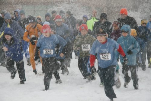
As I was preparing for this falls trip to Belgium, I had to check on an opportunity for participation in an orienteering event. I checked both the Vlaams Verbond voor Oriënteringsport (VVO, the Flemish orienteering federation) and the Fédération Régionale des Sports d'Orientation (FRSO, the Walloon orienteering federation). I was in luck, not in as much as there was an event, but rather because it was so close to my home town of Eupen. With 21 clubs in Belgium (14 in Wallonia, including my old club Orientierungslaufverein Eifel, OLVE and 7 in Flanders), there is an event almost every weekend of the year. The event in question was near Genk, only about 60 km from Eupen. I enjoyed driving past many familiar sites passing Liege on my way to Zutendaal and de Lietteberg map on this beautiful early winter day.
I found the location without any trouble and was immediately impressed by all the hubbub. I could not use my e-punch stick because unlike the SportIdent system adopted within the US Orienteering Federation, the VVO uses the EMIT e-card system instead. Fortunately they had some for rent. Participation fee was an affordable 4 Euro, like in the US a bargain compared to many other sports. It was a remote start and I used the 2 km there as a warm-up. BORASCA, the organizing club had laid nine courses, including three puzzle-Os with a map that was part oro-hydro, plus a kid’s course.
My first challenge was to figure out the e-card system. It was intuitive but I wasn’t sure about whether the card worked. There was no feedback from the CP, like a flashing light or a beep which left me disconcerted. When at CP 7 there was indeed a flashing light, I knew I was in trouble. I am certain that I had correctly laid the card on the device before, it must have been an error.
I did not let this deter me from enjoying the well laid course. I could not get over how different this very domesticated the environment was compared to the wilds of the Upper Midwest in and around Minnesota. Fences were a major feature and vegetation boundaries were often those between different plantings on forest parcels. Tree roots were a common feature for CPs, as were man-made objects. CPs were placed accurately and generally much more visible than those I am used to at MNOC events.
When I returned, my fears that the start and the initial 6 controls had not been recorded on the e-card were confirmed, but the time keepers kindly took the time from my Garmin Forerunner 305 and recorded it for full credit when I explained my predicament. When I e-mailed the BORASCA club contact about the card, I also found out that the competition equipment is provided by VVO and that she would forward my concerns about the e-card not working properly. I am pretty sure I did nothing wron while inserting the card into the initial six controls but in hindsight, I should have familiarized myself with the EMIT e-card before taking off.
I finished dead last in the long event of 8500 m, see Results. I was impressed by the number of participants, in all there were 237 from 15 clubs, plus 8 children. There is something to be said for a small, densely populated country to further sports without mass-market appeal!
Sunday, November 28, 2010
Friday, November 26, 2010
Diepbach Run
I took Thursday off after my 20 km run on the previous day. On Friday I decided to do another run. From Arnulf's house I headed uphill towards Schoenefeld running between the multi-sports complex and the ash running track where I had spent many hours of interval training many years ago, continuing past the monstrosity of the new stadium bleachers that had to be built on the quick when our hometown team, AS Eupen joined the premier league at the end of the last soccer season. The bleachers jut out over the stadium fence and rises easily four to five stories above ground level on top of Frankendelle, the only completed portion of what was to be an express route around town.
I passed the intersection of Schoenefeld and Kehrweg, a place that still bears the name “At the Gallows,” a remnant from darker times when public executions provided deterrent to crime as well as entertainment. I passed Residence Belle Vue, a hotel built in the 1950s in the style of an oversized Swiss chalet, and then several similar buildings, one still under construction. I turn into Opersbach, running past a farm into the woods. Glad to see the fresh tracks in the snow, showing that there are still quite a few runners in my hometown. I jog along the Vita Parcours heading east toward the Diepbach valley. At Diepbach farm, I follow the east side of the valley towards Langestal and the Weser river. Here, I hug the northern hill side heading back towards town while slowly climbing and then falling back towards the Weser. Once at the edge of town, I enter Schorberg after a short but steep climb on Kehrweg. I cross Frankendelle for the last climb towards the youth hostel and finish my run.
Wednesday, November 24, 2010
Hill Wanderung (Descente de la Helle) Trail Run
Today, my brother Arnulf is giving me a ride to Baraque Michel in the High Fen (Hohes Venn), a peat bog area between Eifel and Ardennes, surrounding the highest point of Belgium. From here, I am planning to run along the Hill, a creek descending from the highland fens and joining the Weser in Eupen. This is a classic day hike and there is much lore about the area, especially the fen.
Before motorized transportation, crossing the fen in winter on foot was a dangerous undertaking. Many wanderers lost their way in the fog or in driving snow, and many succumbed to exhaustion and exposure, even into the late 19th century. Small monuments and crosses attest to the locations where their remains were found, like those of the fiancées who on 21 January 1871 left Jalhay for the young woman's hometown Xhoffraix to retrieve their marriage license. They never made it and were found after the snow melt kilometers apart.
My own family history is tied to crossing or rather not being able to cross the fen. When my great-grandfather Caspar Franken moved to the area from Cologne in 1878, he planned to check out Eupen and Malmedy and then decide where to set up his photography business. He visited Eupen and then took the stage coach for Malmedy. In the highlands, the coach could not pass due to deep snow and a storm and needed to return to Eupen. That sealed it, Caspar stayed, became a partner of the local photographer, married a local woman, eventually becoming a successful business man.
Even now every few years the odd group of hikers gets lost and triggers a search. In the early 1980s I had my dad drop me off at Baraque Michel at around 15:30 on Christmas Eve. That time, I did the trip on cross country skis. The start was eerie because the fresh snow cover and the thick fog created a white backdrop, immaculate in its uniformity with the exception of my own tracks which vanished into whiteness a few steps behind me. It was an odd sensation, because I never quite knew whether my next step would be on level ground or down, because while the fen is quite flat, it is marbled with shallow creeks, old drainage ditches and peat pits. I knew that keeping a NE bearing, I would intersect with the edge of a forest. When the whiteness ahead turned first barely noticeably and then more strongly darker, I knew I had my landmark. The rest of the trip was pretty routine, and I made it back to town in about 4 hrs, mostly cutting my own track.
Today, thick snowflakes were falling out of a fog not as dense today as it had been during my xc-outing almost thirty years earlier.
The stretch across the fen is now covered with a boardwalk, to protect the bog from the feet of the thousands of hikers who come to enjoy this beautiful area. I recall that before, the trail was often badly eroded and flanked by almost bottomless bog holes. The boards were covered with 4-5 cm of snow, providing a soft running surface. Fortunately, it was not slick, the hazards came rather from missing boards or slanted sections, where the supports had sunk into the soft ground. I ran past the Cross of the Fiancées and past the officially marked spring of the Hill Creek. At a crossing, a sign indicated 20 km to Eupen.

At one point, a snow-covered sign indicated that the trail was blocked. A little farther down, a section of about 20 m of boardwalk was missing and I had to make my way gingerly through the bog.
From then on, the Hill valley began to sink into the landscape, first very gradually, then more noticeably. Tree stands of birch and fir were now framing the creek.
The boardwalk ended and was replaced by a single track trail intermittently rocky and muddy. When the trail veered off river's edge, it was rather muddy.
When I crossed into a recently logged area, the trail turned into a morass which tried to cross as best as I could, hopping from half-submerged log to log. It did not help, after a few steps, there was nowhere to go but in. I promptly sank into the mire up to my right knee, but that was the only incident of this type. Whoever had questions on why every guide to the area recommends waterproof boots, here is the answer.
I put the wet stretch past me and was promptly confronted with another challenge: the trail took a sharp left, up the steep slope of the river valley, by now at least 40 m deep. On top, a map explained that the creek-side trail was closed “for reasons of safety.” It did not specify if it was my safety or that of the landscape. I assume it was the latter's ...
On top of the slope, I followed the signs posted at regular intervals, crossing a beautiful oak grove and then another fen.
Then the trail turned back to the valley. I had hoped for an end of the detour to oon, because when when I reached the intersection of various forestry roads and trails at the bridge near Porfays, new warnings of detours greeted me. On top of it, the directions were anything but easy to understand. I think I did not take the suggested route when I followed the forestry road towards Seveneiken. It was a pretty boring run and in hindsight I think I should have overruled the signs and stayed in the valley. Thus I ran on the long straight stretch towards Seveneiken. Very close to Seveneiken, after completing 15 km, I broke for a snack of an Eupen specialty, a raisin bread baked in the shape of a stylized human figure only at the time of St. Nicolas called Kloosman. This brought back the tale of a pair of siblings who got lost in the woods after heading home from a St. Nicolas party. They were sustained by their Kloosman until they were found cold, dirty and tired but otherwise unharmed within a day or two.
Before motorized transportation, crossing the fen in winter on foot was a dangerous undertaking. Many wanderers lost their way in the fog or in driving snow, and many succumbed to exhaustion and exposure, even into the late 19th century. Small monuments and crosses attest to the locations where their remains were found, like those of the fiancées who on 21 January 1871 left Jalhay for the young woman's hometown Xhoffraix to retrieve their marriage license. They never made it and were found after the snow melt kilometers apart.
My own family history is tied to crossing or rather not being able to cross the fen. When my great-grandfather Caspar Franken moved to the area from Cologne in 1878, he planned to check out Eupen and Malmedy and then decide where to set up his photography business. He visited Eupen and then took the stage coach for Malmedy. In the highlands, the coach could not pass due to deep snow and a storm and needed to return to Eupen. That sealed it, Caspar stayed, became a partner of the local photographer, married a local woman, eventually becoming a successful business man.
Even now every few years the odd group of hikers gets lost and triggers a search. In the early 1980s I had my dad drop me off at Baraque Michel at around 15:30 on Christmas Eve. That time, I did the trip on cross country skis. The start was eerie because the fresh snow cover and the thick fog created a white backdrop, immaculate in its uniformity with the exception of my own tracks which vanished into whiteness a few steps behind me. It was an odd sensation, because I never quite knew whether my next step would be on level ground or down, because while the fen is quite flat, it is marbled with shallow creeks, old drainage ditches and peat pits. I knew that keeping a NE bearing, I would intersect with the edge of a forest. When the whiteness ahead turned first barely noticeably and then more strongly darker, I knew I had my landmark. The rest of the trip was pretty routine, and I made it back to town in about 4 hrs, mostly cutting my own track.
Today, thick snowflakes were falling out of a fog not as dense today as it had been during my xc-outing almost thirty years earlier.
 |
| Still smiling, just after being dropped off at Baraque Michel by my brother |
At one point, a snow-covered sign indicated that the trail was blocked. A little farther down, a section of about 20 m of boardwalk was missing and I had to make my way gingerly through the bog.
 |
| Boardwalk to nowhere? |
 |
| Hill Creek, more clearly defined |
When I crossed into a recently logged area, the trail turned into a morass which tried to cross as best as I could, hopping from half-submerged log to log. It did not help, after a few steps, there was nowhere to go but in. I promptly sank into the mire up to my right knee, but that was the only incident of this type. Whoever had questions on why every guide to the area recommends waterproof boots, here is the answer.
 |
| That's supposed to be the trail??? |
 |
| To be kept safe? I agree. |
 |
| Oaks in the mist |
 |
| Vaguely, behind the trees: Warrior's Bridge to the left and Black Bridge to the right. |
From Seveneiken it was only a short stretch to the confluence of Hill and Soor creeks, where the Black Bridge (Schwarze Bruecke) crosses Hill creek and Warrior Bridge (Kriegerbruecke) and . Instead of heading the rest of the road towards the public pool (Wetzlaerbad), I crossed the Hill and headed up my last climb, up towards Kanzel und Krone and then towards Binster Weg to my cousin Mark's house. All in all a great run!
Tuesday, November 23, 2010
Stockem-Roereken-Loussack Run
First day back in Eupen, getting up at 7:00: I had to do my old run. Ordinarily, I would have started at my parent's house in Stockem, but since they are in nursing care, I am staying at my brother's house in the middle of town. It is a typical Belgian winter morning, just above freezing, a damp chill cutting through my running outfit without it being really cold. Taking off, I crossed Zentral Park (fka Spitalswiesen (hospital meadows)) and headed up Stockem. Passing Athenaeum school, my alma mater for both primary and secondary school, I was inundated with memories. After all, I had walked, biked or driven that stretch for those twelve years. I ran by the old farm houses and newish villas, by Castle Stockem (Burg Stockem), St. Michael's Chapel (Michaelskapelle) and many other landmarks of my childhood. I ran past my parents' house, only giving it a glance and headed for Roereken, where the cow pastures are. Except for the winter months, the dairy farmers in my neighborhood drove their cattle in for milking mornings and nights and swept the cow pies off to the side of the street, or rather distributed them evenly across the blacktop. Since now is winter, I did not have to contend with this slick film coating the street, and anyway, the milking barns have moved to the pastures and cattle driven on the street is pretty much a thing of the past. Where the blacktop ends and the gentle ridge begins tilting west, towards Membach, the first village in Wallonia, I had to frown my forehead towards the ugly machine shed, sized to accommodate about the five or so monstrous tractors and their implements of an agricultural contractor, right above the pond where I used to fish as a kid. It was built long after I moved away, but it is an eyesore in oh so many ways. The stretch between there and the Chapelle de Notre Dame des Sept Douleurs on top of the Giesberg used to be deeply rutted, now it's filled in with gravel, certainly easier to run on but much less charming. We used to have quite a few bone fires on top of this hill, talking and drinking into a Friday or Saturday summer night.
Heading down the hill towards Membach in a light drizzle, mist shrouding of Hertogen Forest, the northern-most slopes of the Ardennes. I skirt the north-east edge of town, past St. Joseph's nursing home and the cemetery, and once more I am on a dirt road surrounded by hedgerows and pastures. Passing Loussak, an isolated farmhouse I am starting the home stretch, entering Eupen at Waisenbueschchen and returning to my brother's home.
Heading down the hill towards Membach in a light drizzle, mist shrouding of Hertogen Forest, the northern-most slopes of the Ardennes. I skirt the north-east edge of town, past St. Joseph's nursing home and the cemetery, and once more I am on a dirt road surrounded by hedgerows and pastures. Passing Loussak, an isolated farmhouse I am starting the home stretch, entering Eupen at Waisenbueschchen and returning to my brother's home.
Saturday, November 13, 2010
Arctic Commando Trail Run 2010
As during the past two years, I participated in the St. Paul Central HS XC Ski team's fundraising foot race held on Battle Creek Park's hilly trails. Given the season, both previous editions I participated in had been anything but mild. On both occasions, snow flakes were dancing in the air and cold was somewhat of a factor. This year the race could almost have been held on skis, as the first serious winter storm dumped about 20 cm of wet new snow of which 10 cm were already coating the circuit.
I was feeling pretty good going into this even, having worked on my speed including some hill work into my training routine throughout this fall. Based on my experience during the previous year on a wet and slippery track, I was going to use my Inov-8 Mudclaw trail runners, which I had purchased earlier this year, mostly for orienteering. They proved invaluable.
Heavy snow flakes were falling when we lined up at the start and everybody was eager to get going before getting wet and chilled.
After dashing past the young racers who were participating in the 2 mile event, I resisted the urge to get with the lead group. Instead, I joined a guy who seemed to have close to my tempo and stuck to his heels. He was younger and faster rolling down the hills, however he was struggling on the uphill sections where the studs on my Mudclaws came into play.
I was pushing myself, huffing and puffing but hanging in there. With about 1 km remaining, tackling the last uphill, quite a gentle one compared to the rest of them, I pulled alongside. I fully anticipated to fall back again on the next downhill. It turned out that my rival was spent, he waved me on and I quickly put 50 m between him and myself. That distance grew to about a 100 m till the finish and in spite of the difficult conditions I finished 4th of 34, with my best pace, making my best performance yet at this event. For results, see skinnyski. Link to all Arctic Commando trail runs.
I was feeling pretty good going into this even, having worked on my speed including some hill work into my training routine throughout this fall. Based on my experience during the previous year on a wet and slippery track, I was going to use my Inov-8 Mudclaw trail runners, which I had purchased earlier this year, mostly for orienteering. They proved invaluable.
Heavy snow flakes were falling when we lined up at the start and everybody was eager to get going before getting wet and chilled.
 |
| The young'uns leading the pack at the start. Photo by Kathy Waite at skinnyski.com |
I was pushing myself, huffing and puffing but hanging in there. With about 1 km remaining, tackling the last uphill, quite a gentle one compared to the rest of them, I pulled alongside. I fully anticipated to fall back again on the next downhill. It turned out that my rival was spent, he waved me on and I quickly put 50 m between him and myself. That distance grew to about a 100 m till the finish and in spite of the difficult conditions I finished 4th of 34, with my best pace, making my best performance yet at this event. For results, see skinnyski. Link to all Arctic Commando trail runs.
Thursday, November 11, 2010
Veteran's Day Night O at Hyland Park Reserve, Bloomington, MN
This year's edition of the Veteran's Day night event was at Hyland Lake Park Reserve. Registration was at Jan's Place, which I promptly misunderstood to mean one of the MNOC members' home. It turned out to be one of the park facilities and fortunately, I found it right away, unlike Ian's home, which served as departure point for last year's night O at Katherine Abbot Park.
This years event was laid out as a butterfly course, with 3 km, 5 km and 8km distances I picked the middle distance, worrying about screwing up like during the past few events and returning late in the night.
I hit the initial six controls right on. CP 7, however, was a different story, as is immediately evident from the map and my track above, and the satellite image, below. Screwing up on this CP was a mix of outdated map (pond missing), darkness (I would have seen the bigger lake if there had been any light), failure to estimate distance and count steps and my pigheadedness about sticking to a couple of obvious attack points trying each several times without trying a third alternative.

In the end, it's all about thinking. But in spite of my troubles with CP 7 I did manage to pull off a victory in the medium length category: Hyland Park Reserve Night O Results.
This years event was laid out as a butterfly course, with 3 km, 5 km and 8km distances I picked the middle distance, worrying about screwing up like during the past few events and returning late in the night.
I hit the initial six controls right on. CP 7, however, was a different story, as is immediately evident from the map and my track above, and the satellite image, below. Screwing up on this CP was a mix of outdated map (pond missing), darkness (I would have seen the bigger lake if there had been any light), failure to estimate distance and count steps and my pigheadedness about sticking to a couple of obvious attack points trying each several times without trying a third alternative.
In the end, it's all about thinking. But in spite of my troubles with CP 7 I did manage to pull off a victory in the medium length category: Hyland Park Reserve Night O Results.
Subscribe to:
Posts (Atom)