Friday, December 31, 2010

Beginning Cross Country Skiing Season 2010-2011

If previous winter had wonderful conditions for all manner of snow sports, this year is even better. E.g last year just like this, we had an early start to the season. Unlike last year, we did not have a pre-holiday thaw and freezing rain, thus there were a few more skiable days (though it sounds like we will be hit with some rain over the last couple days of 2010).

Overall, I got almost twice as much skiing and skijoring in when compared to last year.

200820092010
Skate Skiing044.6461.64
Skijoring021.5760.9
Classic Skiing14.77013.02
14.7766.21135.57
(
(Distances in km)

I skied mostly on the home courts, i.e. Highland 9-Hole for skijoring and Como for skate skiing. Like last year, I participated in the Como Park Champion ships where my performance showed my improvement in the sport. I had a wonderful interlude at Sugarbush, at Tofte, MN (Lynn had planned this as a family outing but sadly she wasn't able to come along due to a bout of the stomach flu).

On the equipment front, I replaced my damaged '08 Atomic Race Skate. Finn Sisu exchanged them free of charge for a pair of the 2010 model. So far, they have been working great.

Due to some ups and downs in the temps, I have been changing wax before every other session, it seems. My investment in the Toko Ski Vise Nordic and the T14 electronic iron paid off. James appreciates the iron  to wax his skis, I am only afraid that he will scrap up the bottom of the iron with the skis' metal edges.

Wednesday, December 29, 2010

Classic Skiing Homestead Loop, Sugarbush Trails, Tofte, MN

I decided after yesterday's 25 km to make today an easy one and also to use my classic skis, which I have ruefully neglected. After dropping James and Joe at Lutsen, I headed for Sugarbush where I did the Homestead Loop.
Parking to I, right to J, turn back at K, right at J, right at H,
left at G, right at F, left at E, right at C, B and A
Since today's outing was not as remote, I saw many more skiers. All were taking advantage of the unusually mild weather. At J intersection I chatted with some skiers who had come from the Onion River parking lot. They alerted me to some wolf tracks and scat on the trail.
Trail between J and K intersections
I had hoped to take the spur to the overlook above Chateau Leveaux, but my impression from the previous day had been correct, the trail leading south from K intersection was not groomed and looked overgrown. Snowshoes or BC skis might have been the correct mode for this excursion. So I returned to J to continue the Homestead Loop.

Venturing out to K had not at all been in vain as I got to more closely view the mess of wolf and deer tracks which suggested some drama that had very recently unfolded in the middle of the trail.
Dogs on the trail? Nope, it's wolf tracks ...
... and scat. 
After Picnic Loop, today's effort seemed slight to moderate. With the temperature hovering just above freezing, waxing was somewhat tricky. I re-waxed with Swix Purple Extra which came off thick and unwieldy. It was very slow and grippy but eventually brought acceptable performance.

Tuesday, December 28, 2010

Picnic Loop at Sugarbush Trails, Tofte, MN

I should really be putting in a rest day, but it's just so much fun! I woke up early but dozed in my soft bed at Bluefin Bay, listening to the radio until the daylight bekame apparent. I moved into the boy's room and sat in the brigth morning sun, gazing over Lake Superior. A little after 8:00 I started to rouse them and in expectation of a fun day on the slopes, they were soon up and assembling their gear. While waitig for them to get ready,  I studied the map of the Sugarbush Trail System. Since the the weather forecast for the coming days was sketchy, I decided to frontload my program with the long day and chose the Picnic Loop.
Straight from Parking, right at D, I and J, left at K, L, M, and N,
right at O end E and straight back to Parking
After dropping of James and Joe at Lutsen (and getting their ski passes), I headed for the Britton Peak trail head parking lot. There were a few other cars but not a person in sight. I had spoken to the owner of Sawtooth Outfitters where we had rented canoes for our 2009 BWCA trip. He had suggested to do the loop counter-clockwise. I had my hydration pack with a couple of liters of warm water, a couple of candy bars and a banana as well as some layers of warm clothing in the event of an emergency. I also had my fanny pack with my Canon D10 and Garmin Oregon 450, the latter strictly to record my progress. 
The Britton Peak trail head is connected to the Picnic loop via a short spur of green trails. I could quickly tell that the Sugarbush Trail Association is doing an excellent job grooming. the skating surface was firm and the classic track was well defined. Once I left the spur and moved onto the SE portion of the loop, the terrain became slightly more challenging, with gentle but long slopes. It seemed like the spur from K intersection, leading to an overlook point was not groomed, though some folks had broken their own track. I am planning to do a shorter classic ski tomorrow, maybe I'll check out that trail.

Almost the entire leg between K and L looked as though a herd of bison had stomped along. It looked like 4 or 5 people had decided to walk rather than ski. When I turned north from L, the tracks fortunately seized. After the gentle rise on this green leg, black segment started. Over the next 1.5 km, I gained close to 100 m in elevation. The downhills were steep, too, but never dangerously so. The excellent condition of the trail contributed to its safety, too.


I reached an overlook point just as two women arrived from the opposite direction. they graciously agred to take my picture. One of the woman told me that they had just relocated from Alaska to Embarrass, MN. Judging from their choice of abode and recreational activities they must be suckers for the boreal biome and its accompanying climate. In parting, they assured me that the remainder of the loop would be a walk in the park.

In the meantime I was sucking the last of the 2 liters out of my Camelback bladder. The banana and candy bars were wearing off, too and in spite of my trail acquaintance's assurances I was hitting the wall, literally and figuratively. I ascended a thankfully short stretch of trail so steep that I was tempted to walk. I hooked a ski in the soft snow on the side of the trail and kneed down. I made it. I was grateful when O Intersection came about, signalling the end of the long black leg and promising the end of the outing. When I reached the spur to the parking lot I accelerated on the fairly level trail.

The loop combined with today's weather presented an interesting challenge. For my Rex blue, skiing was fast in the sunny patches, though the snow had started to soften where the sun had been shining longer. In the shade, where the snow was holding the colder temps from previous nights, the skiing was much slower.

All in all a great challenge and a wonderful outing on Sugarbush trails.


Sunday, December 26, 2010

Como Park Championships 2010

A beautiful morning, and a perfectly groomed skating surface. I did feel a little queasy to my stomach  but decided to not let that get in the way.

I'm the third in this group, bib #220.
Looks like I am dying, after barely 1/2 of the first of two laps. Pictures can
be seen at skinnyski.com
Very happy with my performance, compared to last year, when my chip time was 39:26.3, while this year's is 34:02.3 .

Happy with my placement, too. 62nd out of 97 starting men. Last year I placed 88th out of 98 starters. See results at endurancepromotions.com. However, there is room for improvement, got to work my technique. 

Friday, December 10, 2010

Pre-Storm Skijor

The augurs of the elements had been unanimous on this one: around midnight on Friday we were to get a good dumping of snow, lasting through at least the entire Saturday. This made me think that Saturday skiing might be challenging, if not impossible, certainly no fun. I was excited about the prospect of solidifying the until now fairly skimpy snow foundation with something more substantial but I did not want to miss out on a day of skiing. So I decided to to take advantage of a beautiful late Friday afternoon and do a couple of laps at Highland.
Mellie, pulling hard!

After work, I changed into more appropriate clothing, grabbed Mellie and the GoPro Hero HD and headed for Highland. Mellie was giddy with excitement and I have to admit, so was I. Much busier during daylight hours than very early mornings or late nights. Highland HS XC Ski team was out and various other skiers, too. After the arduous task of strapping on my skis with an hyper-excited dog tethered to me, I got moving. Some skiers were really hogging the skating lane, two and three abreast; fortunately they scrammed when they saw the Black-Lab-Express bear down on them. One group had another black lab, this one on the lose. He ran over to be friendly with the Mellster, it barely slowed us down. This first lap was likely our fastest at Highland, and the combined two laps was too.

The video was not ideal, because of the sea-sickness inducing motion of my head, and even more so because of a slight mis-orientation of the camera, showing rather more sky than necessary, and not enough dog action. I take it more as a proof-of-concept and will try experimenting.

Wednesday, December 8, 2010

First Skijoring this Winter :)

I damaged my good Atomic Race Skate skis last Sunday at Como in a relatively minor stumble. I did not even hit the ground, but Finn Sisu declared them unsalvageable and said I should stop by to make sure the new ones would fit my weight.

I thought I'd be out a significant wad of cash and I was somewhat taken aback when I saw my old bindings already dangling from a brand new pair of skis. What if I would opt for a less expensive pair I thought to myself. Anyway, I stepped on the skis and they were declared a good fit. I asked what the damage would be and was told in no uncertain terms that there was none, as my old skis were already on the way back to the factory. I was stunned. Another five minutes, time it took to have my bindings professionally mounted, I walked out of Finn Sisu with a brand new pair of Atomic skis in hand. They got themselves a loyal customer yesterday!

I had to try those skis and went out with the Mellster in tow (or more precisely I being in tow of Mellie). So I donned ear muffs, a headlight, my lobster claw mitts and at 5:30 AM with a starry sky overhead and a brisk 3F and crunchy snow on the ground, we were the only ones at the Highland 9-Hole course. Of course that is not counting the three deer that Mellie thought would be a fine breakfast for a physically active dog. Fortunately, I knew from experience how to divert a dog with deer on his mind: I reeled her in on the pull rope and lifted her a bit, something she very much dislikes. The second lap was one of our best, Mellie being very focused, not pulling to hard but leaving no slack in the rope either! A great way to inaugurate those new skis!

Sunday, November 28, 2010

Orienteering at de Lietteberg, Zutendaal, BE

As I was preparing for this falls trip to Belgium, I had to check on an opportunity for participation in an orienteering event. I checked both the Vlaams Verbond voor Oriënteringsport (VVO, the Flemish orienteering federation) and the Fédération Régionale des Sports d'Orientation (FRSO, the Walloon orienteering federation). I was in luck, not in as much as there was an event, but rather because it was so close to my home town of Eupen. With 21 clubs in Belgium (14 in Wallonia, including my old club Orientierungslaufverein Eifel, OLVE and 7 in Flanders), there is an event almost every weekend of the year. The event in question was near Genk, only about 60 km from Eupen. I enjoyed driving past many familiar sites passing Liege on my way to Zutendaal and de Lietteberg map on this beautiful early winter day.

I found the location without any trouble and was immediately impressed by all the hubbub. I could not use my e-punch stick because unlike the SportIdent system adopted within the US Orienteering Federation, the VVO uses the EMIT e-card system instead. Fortunately they had some for rent. Participation fee was an affordable 4 Euro, like in the US a bargain compared to many other sports. It was a remote start and I used the 2 km there as a warm-up. BORASCA, the organizing club had laid nine courses, including three puzzle-Os with a map that was part oro-hydro, plus a kid’s course.

My first challenge was to figure out the e-card system. It was intuitive but I wasn’t sure about whether the card worked. There was no feedback from the CP, like a flashing light or a beep which left me disconcerted. When at CP 7 there was indeed a flashing light, I knew I was in trouble. I am certain that I had correctly laid the card on the device before, it must have been an error.

I did not let this deter me from enjoying the well laid course. I could not get over how different this very domesticated the environment was compared to the wilds of the Upper Midwest in and around Minnesota. Fences were a major feature and vegetation boundaries were often those between different plantings on forest parcels. Tree roots were a common feature for CPs, as were man-made objects. CPs were placed accurately and generally much more visible than those I am used to at MNOC events.

When I returned, my fears that the start and the initial 6 controls had not been recorded on the e-card were confirmed, but the time keepers kindly took the time from my Garmin Forerunner 305 and recorded it for full credit when I explained my predicament. When I e-mailed the BORASCA club contact about the card, I also found out that the competition equipment is provided by VVO and that she would forward my concerns about the e-card not working properly. I am pretty sure I did nothing wron while inserting the card into the initial six controls but in hindsight, I should have familiarized myself with the EMIT e-card before taking off.

I finished dead last in the long event of 8500 m, see Results. I was impressed by the number of participants, in all there were 237 from 15 clubs, plus 8 children. There is something to be said for a small, densely populated country to further sports without mass-market appeal!

Friday, November 26, 2010

Diepbach Run


I took Thursday off after my 20 km run on the previous day. On Friday I decided to do another run. From Arnulf's house I headed uphill towards Schoenefeld running between the multi-sports complex and the ash running track where I had spent many hours of interval training many years ago, continuing past the monstrosity of the new stadium bleachers that had to be built on the quick when our hometown team, AS Eupen joined the premier league at the end of the last soccer season. The bleachers jut out over the stadium fence and rises easily four to five stories above ground level on top of Frankendelle, the only completed portion of what was to be an express route around town.
I passed the intersection of Schoenefeld and Kehrweg, a place that still bears the name “At the Gallows,” a remnant from darker times when public executions provided deterrent to crime as well as entertainment. I passed Residence Belle Vue, a hotel built in the 1950s in the style of an oversized Swiss chalet, and then several similar buildings, one still under construction. I turn into Opersbach, running past a farm into the woods. Glad to see the fresh tracks in the snow, showing that there are still quite a few runners in my hometown. I jog along the Vita Parcours heading east toward the Diepbach valley. At Diepbach farm, I follow the east side of the valley towards Langestal and the Weser river. Here, I hug the northern hill side heading back towards town while slowly climbing and then falling back towards the Weser. Once at the edge of town, I enter Schorberg after a short but steep climb on Kehrweg. I cross Frankendelle for the last climb towards the youth hostel and finish my run.

Wednesday, November 24, 2010

Hill Wanderung (Descente de la Helle) Trail Run

Today, my brother Arnulf is giving me a ride to Baraque Michel in the High Fen (Hohes Venn), a peat bog area between Eifel and Ardennes, surrounding the highest point of Belgium. From here, I am planning to run along the Hill, a creek descending from the highland fens and joining the Weser in Eupen. This is a classic day hike and there is much lore about the area, especially the fen.

Before motorized transportation, crossing the fen in winter on foot was a dangerous undertaking. Many wanderers lost their way in the fog or in driving snow, and many succumbed to exhaustion and exposure, even into the late 19th century. Small monuments and crosses attest to the locations where their remains were found, like those of the fiancées who on 21 January 1871 left Jalhay for the young woman's hometown Xhoffraix to retrieve their marriage license. They never made it and were found  after the snow melt kilometers apart.

My own family history is tied to crossing or rather not being able to cross the fen. When my great-grandfather Caspar Franken moved to the area from Cologne in 1878, he planned to check out Eupen and Malmedy and then decide where to set up his photography business. He visited Eupen and then took the stage coach for Malmedy. In the highlands, the coach could not pass due to deep snow and a storm and needed to return to Eupen. That sealed it, Caspar stayed, became a partner of the local photographer, married a local woman, eventually becoming a successful business man.

Even now every few years the odd group of hikers gets lost and triggers a search. In the early 1980s I had my dad drop me off at Baraque Michel at around 15:30 on Christmas Eve. That time, I did the trip on cross country skis. The start was eerie because the fresh snow cover and the thick fog created a  white backdrop, immaculate in its uniformity with the exception of my own tracks which vanished into whiteness a few steps behind me. It was an odd sensation, because I never quite knew whether my next step would be on level ground or down, because while the fen is quite flat, it is marbled with shallow creeks, old drainage ditches and peat pits. I knew that keeping a NE bearing, I would intersect with the edge of a forest. When the whiteness ahead turned first barely noticeably and then more strongly darker, I knew I had my landmark. The rest of the trip was pretty routine, and I made it back to town in about 4 hrs, mostly cutting my own track.

Today, thick snowflakes were falling out of a fog not as dense today as it had been during my xc-outing almost thirty years earlier.
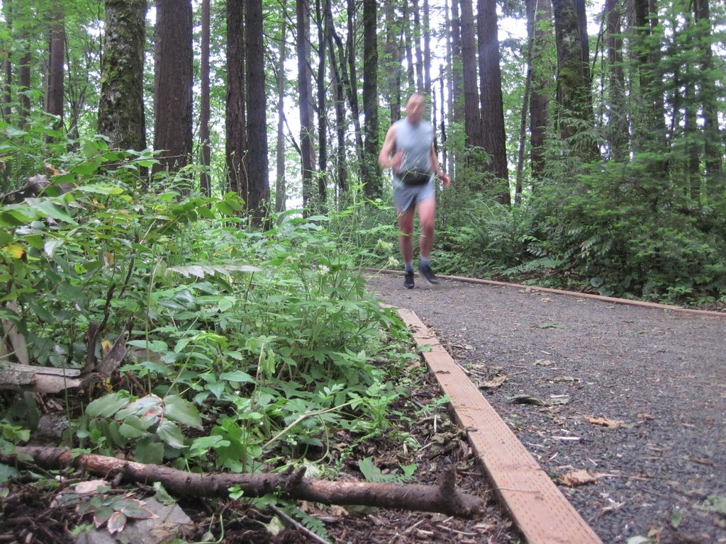
Still smiling, just after being dropped off at Baraque Michel by my brother
The stretch across the fen is now covered with a boardwalk, to protect the bog from the feet of the thousands of hikers who come to enjoy this beautiful area. I recall that before, the trail was often badly eroded and flanked by almost bottomless bog holes. The boards were covered with 4-5 cm of snow, providing a soft running surface. Fortunately, it was not slick, the hazards came rather from missing boards or slanted sections, where the supports had sunk into the soft ground. I ran past the Cross of the Fiancées and past the officially marked spring of the Hill Creek. At a crossing, a sign indicated 20 km to Eupen.

At one point, a snow-covered sign indicated that the trail was blocked. A little farther down, a section of about 20 m of boardwalk was missing and I had to make my way gingerly through the bog.
Boardwalk to nowhere?
From then on, the Hill valley began to sink into the landscape, first very gradually, then more noticeably. Tree stands of birch and fir were now framing the creek.
Hill Creek, more clearly defined
The boardwalk ended and was replaced by a single track trail intermittently rocky and muddy. When the trail veered off river's edge, it was rather muddy.

When I crossed into a recently logged area, the trail turned into a morass which tried to cross as best as I could, hopping from half-submerged log to log. It did not help, after a few steps, there was nowhere to go but in. I promptly sank into the mire up to my right knee, but that was the only incident of this type. Whoever had questions on why every guide to the area recommends waterproof boots, here is the answer.
That's supposed to be the trail???
I put the wet stretch past me and was promptly  confronted with another challenge: the trail took a sharp left, up the steep slope of the river valley, by now at least 40 m deep. On top, a map explained that the creek-side trail was closed “for reasons of safety.” It did not specify if it was my safety or that of the landscape. I assume it was the latter's ...

To be kept safe? I agree.
On top of the slope, I followed the signs posted at regular intervals, crossing a beautiful oak grove and then another fen.

Oaks in the mist
Then the trail turned back to the valley. I had hoped for an end of the detour to oon, because when when I reached the intersection of various forestry roads and trails at the bridge near Porfays, new warnings of detours greeted me. On top of it, the directions were anything but easy to understand. I think I did not take the suggested route when I followed the forestry road towards Seveneiken. It was a pretty boring run and in hindsight I think I should have overruled the signs and stayed in the valley. Thus I ran on the long straight stretch towards Seveneiken. Very close to Seveneiken, after completing 15 km, I broke for a snack of an Eupen specialty, a raisin bread baked in the shape of a stylized human figure only at the time of St. Nicolas called Kloosman. This brought back the tale of a pair of siblings who got lost in the woods after heading home from a St. Nicolas party. They were sustained by their Kloosman until they were found cold, dirty and tired but otherwise  unharmed within a day or two.
Vaguely, behind the trees: Warrior's Bridge to the left
and Black Bridge to the right.
From Seveneiken it was only a short stretch to the confluence of Hill and Soor creeks, where the Black Bridge (Schwarze Bruecke) crosses Hill creek and Warrior Bridge (Kriegerbruecke) and . Instead of heading the rest of the road towards the public pool (Wetzlaerbad), I crossed the Hill and headed up my last climb, up towards Kanzel und Krone and then towards Binster Weg to my cousin Mark's house. All in all a great run!

Tuesday, November 23, 2010

Stockem-Roereken-Loussack Run

First day back in Eupen, getting up at 7:00: I had to do my old run. Ordinarily, I would have started at my parent's house in Stockem, but since they are in nursing care, I am staying at my brother's house in the middle of town. It is a typical Belgian winter morning, just above freezing, a damp chill cutting through my running outfit without it being really cold. Taking off, I crossed Zentral Park (fka Spitalswiesen (hospital meadows))  and headed up Stockem.  Passing Athenaeum school, my alma mater for both primary and secondary school, I was inundated with memories. After all, I had walked, biked or driven that stretch for those twelve years. I ran by the old farm houses and newish villas, by Castle Stockem (Burg Stockem), St. Michael's Chapel (Michaelskapelle) and many other landmarks of my childhood. I ran past my parents' house, only giving it a glance and headed for Roereken, where the cow pastures are. Except for the winter months, the dairy farmers in my neighborhood drove their cattle in for milking mornings and nights and swept the cow pies off to the side of the street, or rather distributed them evenly across the blacktop. Since now is winter, I did not have to contend with this slick film coating the street, and anyway, the milking barns have moved to the pastures and cattle driven on the street is pretty much a thing of the past. Where the blacktop ends and the gentle ridge begins tilting west, towards Membach, the first village in Wallonia, I had to frown my forehead towards the ugly machine shed, sized to accommodate about the five or so monstrous tractors and their implements of an agricultural contractor, right above the pond where I used to fish as a kid. It was built long after I moved away, but it is an eyesore in oh so many ways. The stretch between there and the Chapelle de Notre Dame des Sept Douleurs on top of the Giesberg used to be deeply rutted, now it's filled in with gravel, certainly easier to run on but much less charming. We used to have quite a few bone fires on top of this hill, talking and drinking into a Friday or Saturday summer night.

Heading down the hill towards Membach in a light drizzle, mist shrouding of Hertogen Forest, the northern-most slopes of the Ardennes. I skirt the north-east edge of town, past St. Joseph's nursing home and the cemetery, and once more I am on a dirt road surrounded by hedgerows and pastures. Passing Loussak, an isolated farmhouse I am starting the home stretch, entering Eupen at Waisenbueschchen and returning to my brother's home.

Saturday, November 13, 2010

Arctic Commando Trail Run 2010

As during the past two years, I participated in the St. Paul Central HS XC Ski team's fundraising foot race held on Battle Creek Park's hilly trails. Given the season, both previous editions I participated in had been anything but mild. On both occasions, snow flakes were dancing in the air and cold was somewhat of a factor. This year the race could almost have been held on skis, as the first serious winter storm dumped about 20 cm of wet new snow of which 10 cm were already coating the circuit.

I was feeling pretty good going into this even, having worked on my speed including some hill work into my training routine throughout this fall. Based on my experience during the previous year on a wet and slippery track, I was going to use my Inov-8 Mudclaw trail runners, which I had purchased earlier this year, mostly for orienteering. They proved invaluable.

Heavy snow flakes were falling when we lined up at the start and everybody was eager to get going before getting wet and chilled.
The young'uns leading the pack at the start.
Photo by Kathy Waite at skinnyski.com
After dashing past the young racers who were participating in the 2 mile event, I resisted the urge to get with the lead group. Instead, I joined a guy who seemed to have close to my tempo and stuck to his heels. He was younger and faster rolling down the hills, however he was struggling on the uphill sections where the studs on my Mudclaws came into play.

I was pushing myself, huffing and puffing but hanging in there. With about 1 km remaining, tackling the last uphill, quite a gentle one compared to the rest of them, I pulled alongside. I fully anticipated to fall back again on the next downhill. It turned out that my rival was spent, he waved me on and I quickly put 50 m between him and myself. That distance grew to about a 100 m till the finish and in spite of the difficult conditions I finished 4th of 34, with my best pace, making my best performance yet at this event.  For results, see skinnyski.

Link to all Arctic Commando trail runs.

Thursday, November 11, 2010

Veteran's Day Night O at Hyland Park Reserve, Bloomington, MN

This year's edition of the Veteran's Day night event was at Hyland Lake Park Reserve. Registration was at Jan's Place, which I promptly misunderstood to mean one of the MNOC members' home. It turned out to be one of the park facilities and fortunately, I found it right away, unlike Ian's home, which served as departure point for last year's night O at Katherine Abbot Park.

This years event was laid out as a butterfly course, with 3 km, 5 km and 8km distances I picked the middle distance, worrying about screwing up like during the past few events and returning late in the night.

I hit the initial six controls right on. CP 7, however, was a different story, as is immediately evident from the map and my track above, and the satellite image, below. Screwing up on this CP was a mix of outdated map (pond missing), darkness (I would have seen the bigger lake if there had been any light), failure to estimate distance and count steps and my pigheadedness about sticking to a couple of obvious attack points trying each several times without trying a third alternative.

In the end, it's all about thinking. But in spite of my troubles with CP 7 I did manage to pull off a victory in the medium length category: Hyland Park Reserve Night O Results.

Sunday, October 24, 2010

Mississippi-Minnesota Rivers Confluence 10K Tercet

Fall and ice hockey season are upon us which means that I spend a significant amount of my running in the SW corner of Minnesota's capital city, St. Paul. Departure location is usually Highland Arena, next to the water towers at Snelling Av. and Ford Pkwy. It's nice to start one's workout with a leisurely downhill jog. The problem is that the bitter end involves several challenging hill climbs. I had a chance to run my three standard options of about 10 km each over the past 10 days or so. They can be combined to create 15 km challenges. Though in a busy metropolitan area and near MSP International Airport, the lack of street noise and buildings lets one forget that this is literally in the middle of the city. I have seen wild turkey, deer and other forms of urban wildlife. During one of our first runs together, Mellie treed a good-sized raccoon.

1. Hidden Falls-Crosby Farm Run (10.5 km)

I typically start this run leaving from the overflow parking lot south of the Highland Arena. I run across Snelling, take Bohland Ave to Cleveland, make a dog leg to Ford Pkwy and then follow Mississippi River Blvd south to the steps at the south end of the Ford Plant, leading down to Hidden Falls Park and the Mississippi River banks. The uneven steps and the following trail can be slow and tricky, especially in the dark and when covered with leaves or with ice. An alternative down to the river would be Hidden Falls Drive, official road access to the park, near Magoffin Ave, just past the hair pin turn on E River Rd. Either way, it's easy to tie then into the well developed trail system running along the Mississippi. I follow this to Crosby Farm Road, where I begin my climb out of the valley, along Davern, first crossing Sheppard Rd and then W 7th. Davern St. Hill is the major challenge of this run but also the sign that it's almost over.

2. Crosby Farm Run (10 km)

In this variant, I run S on Snelling and then turn W on Edgecumbe Pkwy. I follow Edgcumbe down the hill to the intersection with St. Paul Ave. There are two options here: either W on Worcester, to where, as Worcester turns into Colette Pl., a pedestrian walkway heads S between two houses and then across the RR tracks to S Prior. The other option is to follow Edgecumbe to the tracks and head W on the bike trail, which then joins with the aforementioned pedestrian walkway. Either way I follow Prior to Mississippi River Blvd, where I immediately descend to the river bottoms, still on Prior, which turns into the park road. There are various options for trails heading in a general downriver direction. My preferred in the dark is to take the trail left at the fork past the E parking lot at Crosby Farms. This runs along the N side of Upper Lake and then crosses a wetland on a boardwalk. In the dark, Mellie and I have been startled several times by big dear crashing through the underbrush in this area. The trail then turns left and generally follows Crosby Lake until it reaches the service road dropping in from Sheppard.

This last time, taking advantage of a day-time run, I tried a single track variant following the bottom of the bluff. I had noticed the trail head on several occasions but had not dared taking it in the dark. It is well used and developed, with stretches of crushed limestone. There were a few muddy spots, I assume from springs, as we did not have rain in quite a few weeks. I saw three fellow dog owners, all like me with well-behaved pooches off their leash. Emerging from the park, it's back in the city, first crossing Sheppard Road, following Elway St. to Montreal to Snelling and back to the arena. Montreal is a good climb, not too steep but long. For a little more excitement and a better hill workout, I occasionally take the steps climbing towards the Frisbee golf course from the intersection of Lexington and Montreal. They are quite hidden and easy to miss.

3. Fort Snelling Loop (12.5 km)

Probably the most challenging of the loops, depending on variations. I head towards the river, as with option 1 generally following Ford Pkwy. Instead of getting onto Mississippi River Blvd, I cross the river on the Ford Bridge and turn S onto the Veteran's Home property. From here I most often take the bridge crossing the Minnehaha Cr. valley and then tie into Fort Snelling State Trail that gradually descends into the Mississippi Valley. Today, having daylight and feeling a bit adventurous I followed the Creek to its confluence with the River and then went along one of my favorite single tracks. It was quite tricky, because of leaf litter and trees that are leaning ever deeper to the ground, requiring some crawling. There are also quite a few steep climbs and descents where the trail avoids natural obstacles. The rocky trail becomes wider at the dog park. No dogs playing today, I could sense Mellie's disappointment. The first climbing challenge is getting back to the Ft. Snelling State Trail. Today, we achieved this by climbing some rough log steps. The next challenge comes immediately after the trail goes under the Hwy 5 bridge: climbing from just above river level to the gates of Ft. Snelling. From there, heading to the trail crossing the river along Hwy 5 completes the Ft. Snelling looplet. Now, I am basically following my approach of the park in option 2, crossing the tracks from Prior and heading to Davern Hill the last and certainly not least hill challenge. But after only five more minutes I can change into something dry and await the return of my hockey player.

Thursday, September 30, 2010

Orienteering at Willow River State Park

I am fond of Willow River and I like the orienteering map for this park. I did, however, not have a good orienteering experience, due to a number of stupid mistakes I made. As usual, I did the red course.

I made a minor mistake approaching C1. I was passing a group and one of the guys challenged me that he'd make it to the control before me. Coming from W along a trail, I needed to pass between two small wetlands and then turn S to move to the E side of the southern wetland and to the control. In the heat of the pursuit, I turned S on the W side of the wetland and ended up sloshing through some water. Oh well, I did not have to worry about keeping my feet dry any longer.

C2 looked very straightforward, A depression in the middle of an embankment. I used followed the road and took a bearing form the turn-off at the first campground. It should have been a straight shot and it was. I ended up at most 20 m to the E of C2, at the beginning of another shallow depression. Thinking this was the one and followed it to the E end. No control. Instead of backtracking I searched for another depression E of the one I entered, no luck. I finally returned , I could have kicked myself it was so obvious. I think I would have seen it when I got to the first depression and looked over my shoulder.
C3 posed no problem but C4 was my worst. 24+ minutes for less than 400 m. Instead I decided to follow a bearing, which was next to impossible in this mess of ravines heavily overgrown with buckthorn. After erring through this maze for a while I decided to do what I should have done leaving C3: I headed for the trail along the meadow on top of the plateau and followed it to the corner in the vegetation border. Bingo, no problem!
I then progressed fairly well, even making some good time through the grassy expanse along the eastern edge of the park. My last mistake was C13, where I was too tentative rounding (or crossing) the ridge to find the reentrant with the control. I felt pretty dejected and humbled with my worst performance since the time I actually gave up at Sand Dunes State Forest. (Results for Willow River Meet at MNOC web page)

On the upside, the deer were thick, I saw probably seven or eight, some from just a few steps away. I also saw a pair of pileated woodpeckers. All in all a nice afternoon in the woods, but poor orineteering performance. Also, after three O-events my Inov-8 Mudclaws are getting used to my feet, or is it the other way around? No more heel blisters after 11 km in the woods.

Saturday, September 11, 2010

Orienteering at Lebanon Hills Regional Park, Eagan

Finally another orienteering event. This spring, I had a dearth of races even though or maybe rather because orienteering kept me quite busy with setting the May Afton SP event.

I had family visiting from Belgium, my uncle Tony, his grandson Yannick and Yannick's cousin Laeticia. It was their last day in the States and I was glad when they agreed to come along. They even agreed to participate in the event, picking the orange course, while I did red.


I felt a little rusty ad a little rushed, though I am in pretty decent physical shape. After giving Tony et al. a quick intro into the art of orienteering and seeing them off, I started. As usual I did not take enough time to read the map, hustling instead from control to control, making a number of minor mistakes. E.g. I overshot C2, even though it was right on a stream which I crossed on a small bridge. After I corrected and knocked off C2, I followed the creek and various wetlands towards C3 almost stumbling over a monstrous snapping turtle. I literally vaulted over the beast, hoping it would decide to take a bite out of me. Fortunately it mad its long neck short, letting me pass unscathed.

Until C7, I was always very close to the control. C4 was a little tricky because of a little peninsula jutting out into Holland lake that looked just like the one on the map. I should have paid attention to the contour and counted reentrants instead. I damned the overgrow white areas, especially the brambles.

I made my firs major mistake heading for C8. All of a sudden I found myself on the wrong side of a narrow strait between two lakes, the little like just to the east of Jensen Lake and whatever is east of it.  After probing the ground with a stick, I decided to try my luck wading across. I was lucky, no bottomless muck or quicksand, but it is the wettest I've gotten during any O-meet, except maybe from sweat or from rain. To balance out this bad mistake, I followed it up with another one, while heading to C9. Must be that the dead fall, blackberry brambles, swamps and steep hills weren't enough of a challenge. From here on my mistakes, if any, were fortunately minor and I made it back in 1:49. Not a good time but at least I found all controls ... (Lebanon Hills Results at MNOC site)

As I was catching my breath I noticed the absence of my Belgian visitors. So I waited, chatting with club mates, always keeping a furtive eye on the direction from where I was expecting them. At long last I couldn't stand it any longer and started to do Orange backwards. at C8, I asked a pair of woman orienteerers whether they had seen an older man in the company of two youngsters. they had, just a couple of controls back, and to my big relief they also said that they looked like they knew what they were doing.  I decided to head back, picking up C7 on the way. Sure enough enough, there were Laeticia and Yannick, sitting at a picnic table reviewing their route. They had decided to call it a day after they could not find C8. Yannick trial and tribulation had been seeing a garter snake.

I wore my Inov-8 Mudclaws after taping my heels with hockey tape to prevent blisters from forming. It worked, and they did rather well at shedding the water from my wading adventure. 

Sunday, June 27, 2010

Bike Ride Eagan-Farmington-Hastings-Eagan

Nice bike outing with some colleagues from Thomson Reuters and the MN Boat Club. They were poopooing my rickety old bike but they could not drop me ... I did get that wobbly wheel fixed, though ...


Christian, Christine, Martin Carlos & Jack

Monday, June 14, 2010

Portland, OR: Back on the Wildwood Trail

I could not resist, I had to head for Washington Park again, first, because I messed up on my original route, and second, because I loved the trails through the forest so much. Thus I found myself back on the Wildwood Trail, this time coming from Burnside St., as originally intended.


I took a different direction, heading yet further up. I asked a woman walking her lab (people with labs are nice!) if I could return to the south end of the park following the Magnolia Trail which she confirmed.


The tall firs were impressive and blocked out most of the light on this overcast morning.

As I returned to the hotel I took note of the chill, noticeable by the redness where my wet running shirt had stuck to my skin. I should have worn some warmer clothing ...

Sunday, June 13, 2010

Portland, OR: Willamette River Run

A benign run along a river. I crossed to the east bank of the river at Burnside Bridge, running a gauntlet of homeless people in their sleeping bags, bedded on either side of Burnside Ave.

Nice vistas of downtown and the environs, but the noise from Hwy 5 on the east bank of the river was a nuisance. At the Portland Opera I asked a fellow runner if I could cross the river at Ross Island Bridge. He thought it might be possible but difficult. I ran up a ramp to Hwy 5 under construction, but no way to get to the bridge. I then ran to the bridge on the river trail, hoping there might be a stairway. Non such. So I turned back and crossed at Hawthorne Bridge.


A beautiful view of downtown Portland on this glorious morning. The flat terrain and the absence of interruptions by traffic lights made for a decent pace.

Saturday, June 12, 2010

Portland, OR Jog from Embassy Suites to Washington Park

God morning for a jog, overcast but cool and dry. Woke up early because of jet lag scouted out a possible route and headed outside. I did not seem to be able to hit Burnside Street, it turned out that the intersection was just a couple of blocks north from where I started while I was heading south.

When I saw the street sign for Jefferson, my planned return route about two blocks ahead, I decided to simply strike out for the hills, abandoning my original route. I started running up Salmon St. and after  a quick dogleg Park Pl. When I saw a group of runners heading towards me, I shouted to them "Is this the way to the arboretum" to which they responded "always straight ahead." I continued uphill. Before long I reached the edge of Washington Park, right by an obelisk.


Looking down Park Ave. from the monument at south end of Washington Park


Uphill from there, some times steeper than others, like these stairs up to Parkview Dr.


Soon leveling off, when I reentered the park to run the Wildwoods Trails. Beautiful!


Back down into the valley, exiting park near Reservoir #4 and Vista Ave Bridge.


Returning along the home stretch, Willamette River, here at Hawthorne Bridge.